|
Bayonne, New Jersey
Maps & Streets |
 |
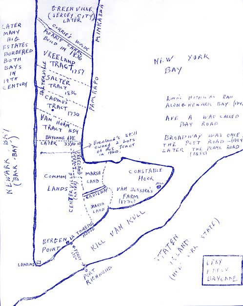
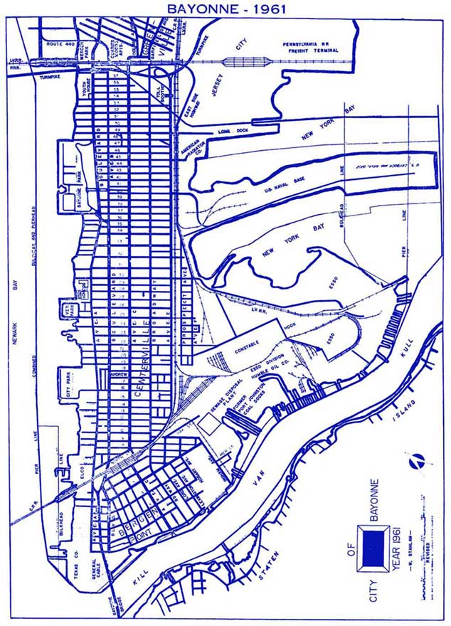
For your convenience, here a just a few maps of Bayonne. Click on the map
images and a new window will open with a larger view of the map. You may have to
disable your popup blocker if a new windows does not appear. Below the three
maps, are the names of streets in Bayonne that changed in accordance with an
ordinance changing the names of 67 streets. It was passed January 3, 1888. On
February 21, 1888, an ordinance was passed by the Council to provide for the
numbering of houses by consecutive numbers for convenience and identification. Thanks go to Walter Stupinski for sending this information!
Previous Street Name
Latourette Street
South Street
15th Street
16th Street
Humphrey's Street
Meigs & Elm Streets (Elm was eastern portion)
18th & Robin Streets (Robin was eastern portion)
Van Buskirk Avenue
19th Street
20th Street
21st Street
22nd Street
23rd Street
24th Street
25th Street
Summit Street
26th Street
27th Street
28th Street
29th Street
30th Street
31st Street
32nd Street
33rd Street
34th Street
Chestnut Avenue
Maple Avenue
Oakland Avenue
Bayonne Avenue
Huron Avenue
Division Street
Southview Avenue
Seaview Avenue
Fairview Avenue
Cadmus Avenue
Bayview Avenue
Westview Avenue
Northview Avenue
41st Street
42nd Street
43rd Street
44th Street
45th Street
46th Street
47th Street
48th Street
49th Street
50th Street
51st Street
52nd Street
53rd Street
54th Street
55th Street
56th Street
Avenue B (South of South St.)
Avenue O
Avenue P
Avenue Q
Avenue R
Avenue S
Avenue T
Avenue U
Avenue V
Avenue W
Brighton Street
East Street
Crescent Avenue |
renamed to
renamed to
renamed to
renamed to
renamed to
renamed to
renamed to
renamed to
renamed to
renamed to
renamed to
renamed to
renamed to
renamed to
renamed to
renamed to
renamed to
renamed to
renamed to
renamed to
renamed to
renamed to
renamed to
renamed to
renamed to
renamed to
renamed to
renamed to
renamed to
renamed to
renamed to
renamed to
renamed to
renamed to
renamed to
renamed to
renamed to
renamed to
renamed to
renamed to
renamed to
renamed to
renamed to
renamed to
renamed to
renamed to
renamed to
renamed to
renamed to
renamed to
renamed to
renamed to
renamed to
renamed to
renamed to
renamed to
renamed to
renamed to
renamed to
renamed to
renamed to
renamed to
renamed to
renamed to
renamed to
renamed to
renamed to |
New Street Name of 1888
6th
Street
7th Street
Linden
8th Street
9th Street
10th Street
11th Street
12th Street
13th Street
14th Street
15th Street
16th Street
17th Street
18th Street
19th Street
20th Street
21st Street
22nd Street
23rd Street
24th Street
25th Street
26th Street
27th Street
28th Street
29th Street
30th Street
31st Street
32nd Street
33rd Street
34th Street
35th Street
41st Street
42nd Street
43rd Street
44th Street
45th Street
46th
Street
47th Street
48th Street
49th Street
50th Street
51st Street
52nd Street
53rd Street
54th Street
55th Street
56th Street
57th Street
58th Street
59th Street
60th Street
61st Street
62nd Street
63rd Street
Meigs Ave. (JFK Blvd. S. of 7th St.)
Rathbun
Avenue
Humphrey's Avenue
Newman Avenue
Avenue C
Avenue D
Lord Avenue
Lexington Avenue
Hobart Avenue
Clinton Avenue
Brighton Avenue
East Avenue
Avenue E |
NOTE - Other, little known streets, have appeared on maps (Ex. down
at the Hook & on the tip of land occupied by Texaco) but no longer
exist. They have not been included.
|